
Beacons View, near Monmouth
Walk through heathland and woodland

Fforest Fawr woodland is near Castell Coch, one of the most picturesque castles in Wales.
There are three walking trails from the Fforest Fawr car park including a sculpture trail for families, and another walking trail from the Castell Coch car park.
Along the walks, you will notice some mounds and hollows which are iron-mining workings and their adjacent spoil tips, now overgrown with vegetation.
Fforest Fawr is a mixed woodland and it has patches of bluebells, wood anemones and wild garlic in the spring.
The woodland is frequently used as a film location for productions ranging from Welsh historical dramas to children's TV programmes – scenes from Merlin and Sherlock have been shot here.
The walking trails are waymarked from start to finish.
Look out for the information panel at the start of the trails.
Find out about walking trail grades.
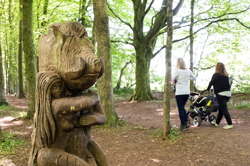
Discover some of the unusual residents of Fforest Fawr along this sculpture trail for families.
At the far end of the trail enjoy a panoramic view of the valley and surrounding hills.
You can see the dramatic Three Bears Cave mine remains - otherwise known as the Three Arches.
The caves are too dangerous to visit but you can see them from behind a fence.
Don’t miss the Three Bears Cave old iron-mining workings - the caves are too dangerous to visit but you can see them from behind a fence.
The Burges’ Way is a walk from the Castell Coch car park around the western end of Fforest Fawr.
Fforest Fawr is on the Taff Trail.
The Taff Trail runs for 55 miles between Cardiff and Brecon along a mixture of riverside paths, railway paths and forest roads.
The Taff Trail is part of the National Cycle Network, cared for by Sustrans.
For more information go to the Sustrans website.
Castell Coch (which means red castle in Welsh) rises dramatically out of Fforest Fawr’s beech woods.
Built on the ruins of a medieval castle, Castell Coch is an excellent example of Victorian Gothic Revival.
The castle has a commanding view of the Taff Gorge and is a landmark on the A470.
The castle is managed by Cadw and the toilets and tearoom are only for visitors who have paid the entry fee.
For more information about visiting Castell Coch go to the Cadw website.
We want you to return home safely after your visit here.
You are responsible for your own safety as well as the safety of any children and animals with you during your visit.
For advice and tips to help you plan your visit here go to Visiting our places safely.
See the top of this webpage for details of any planned closures or other changes to visitor facilities here.
For your safety, always follow instructions from staff and signs including those for trail diversions or closures.
We may divert or close trails whilst we undertake maintenance work or other operations and we may need to close other visitor facilities temporarily.
In extreme weather, we may close facilities at short notice due to the risk of injury to visitors and staff.
Please always follow any instructions on site and any temporary diversion signs.
Fforest Fawr is 4½ miles south west of Caerphilly.
It straddles the county borders of Cardiff and Rhondda Cynon Taf.
Fforest Fawr is on Ordnance Survey (OS) map 151.
The OS grid reference is ST 142 839.
From Caerphilly, follow signs onto the A470 towards Cardiff.
Follow the A470 for around 1½ miles before taking the exit signposted to Castell Coch.
Follow the signs for Castell Coch.
Continue past the castle entrance and the Fforest Fawr car park is on the left after approximately 1¼ miles.
The nearest mainline railway station is in Taffs Well.
For details of public transport visit the Traveline Cymru website.
Car parking is free of charge.
Overnight parking is not permitted.
There are no staff at this location.
Contact our customer team for general enquiries during office hours, Monday to Friday.


